
Where is Mount Everest Located in World Map?
Published On : 11th Jan, 2026 By Adventure

Mount Everest, the Earth's highest mountain above sea level, continues to capture the imaginations of adventurers, travelers, geographers, and mountain enthusiasts worldwide. With a staggering height of 8,848.86 meters (29,031.7 feet), it towers over the Himalayan mountain range and stands as a powerful symbol of natural wonder and human endurance.
But where exactly is Mount Everest located in the world? What makes its location so significant, and why does it draw thousands of climbers and trekkers every year? In this blog, we’ll explore in depth the exact location of Mount Everest on the world map, its geographical context, countries it borders, and how you can identify it using coordinates and maps.
Geographical Location of Mount Everest
Mount Everest is situated on the continent of Asia, more specifically in South Asia, and lies directly on the international border between Nepal and the Tibet Autonomous Region of China. It is a part of the Mahalangur Himal sub-range of the Himalayas.
Key Location Details:
- Continent: Asia
- Mountain Range: Himalayas
- Sub-range: Mahalangur Himal
- Countries: Nepal and China (Tibet)
- Region: South Asia
- Coordinates: 27.9881° N, 86.9250° E
These coordinates place Everest in the Khumbu region of Nepal, within Sagarmatha National Park, a protected UNESCO World Heritage Site.
Mount Everest in the Context of the World Map
To find Mount Everest on a world map, you need to focus on the Asian continent, zooming into the region between India and China. Nepal is a small, landlocked country bordered by India to the south, east, and west, and by China (Tibet Autonomous Region) to the north.
Mount Everest lies in the northeastern part of Nepal, adjacent to the Tibet border. The southern slopes of Everest are in Nepal, while the northern slopes fall within the territory of Tibet.
How to Find Mount Everest on a Map:
- Open a world map and locate the continent Asia.
- Identify India and move northward to locate Nepal.
- Trace upward toward the Himalayas—the world’s tallest mountain range.
- Mount Everest lies right on the Nepal-China border, just north of Lukla and Namche Bazaar, two common starting points for Everest treks.
You can also use tools like Google Maps or Google Earth and enter the coordinates 27.9881° N, 86.9250° E to pinpoint Mount Everest with accuracy.
The Himalayas and Mount Everest
Mount Everest is part of the vast Himalayan Mountain Range, which stretches across five countries:
- India
- Nepal
- Bhutan
- China (Tibet)
- Pakistan
The Himalayas were formed by the collision of the Indian Plate and the Eurasian Plate, a process that is still ongoing. This tectonic movement causes the mountains, including Mount Everest, to rise by a few millimeters each year.
The Mahalangur Himal sub-range, where Everest is located, also includes other towering peaks like:
- Lhotse (8,516 m)
- Makalu (8,485 m)
- Cho Oyu (8,188 m)
Political Geography: Countries Sharing Mount Everest
Mount Everest is one of the few natural wonders in the world that straddles an international border.
1. Nepal
- Southern side of Mount Everest
- Known locally as Sagarmatha (meaning "Forehead in the Sky")
- Home to Sagarmatha National Park and the Everest Base Camp trek
- Most popular and accessible route for climbers and trekkers
2. China (Tibet Autonomous Region)
- Northern side of Mount Everest
- Known in Tibetan as Chomolungma (meaning "Goddess Mother of the World")
- The north route offers a different climbing experience with fewer crowds
Most climbers choose the Nepalese side for ascents, thanks to better access, support infrastructure, and trekking tourism.
Local Geography and Access Points
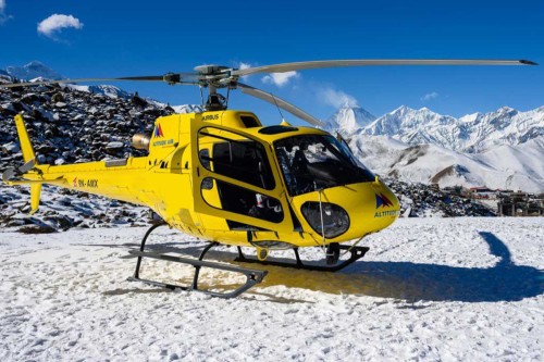
To reach Mount Everest, most travelers fly into Tribhuvan International Airport in Kathmandu, the capital of Nepal. From there, they take a domestic flight to Lukla, a small town with a famously short and high-altitude airport.
From Lukla, trekkers begin their journey through:
- Phakding
- Namche Bazaar (the Sherpa capital)
- Tengboche
- Dingboche
- Lobuche
- Gorakshep
Eventually arriving at Everest Base Camp (EBC) at an altitude of 5,364 meters (17,598 feet).
On the Tibetan side, access is granted through Lhasa, and travelers journey overland via the Friendship Highway to Rongbuk Monastery, the base camp on the northern side.
Mount Everest Coordinates and Mapping
If you're using a GPS device or an app like Google Earth, you can locate Mount Everest using the following geographic coordinates:
- Latitude: 27.9881° North
- Longitude: 86.9250° East
These coordinates represent the summit point, the highest location on Earth.
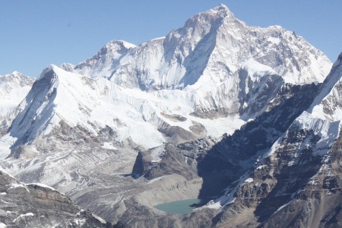
Various mapping tools offer high-resolution imagery of the Everest region, showcasing the mountain's distinct pyramid shape, glaciers, icefalls, and surrounding peaks.
Cultural and Environmental Significance
The area around Mount Everest is not just important geographically but also culturally and ecologically.
Cultural Importance:
- Sacred Mountain: Revered by Sherpas and Tibetans
- Spiritual Significance: Pilgrimages and rituals are often held by locals
- Legends and Myths: Deeply embedded in local folklore
Environmental Significance:
- Sagarmatha National Park: UNESCO World Heritage Site
- Unique Flora and Fauna: Home to snow leopards, red pandas, and Himalayan tahr
- Glacial Systems: Key source for rivers like the Ganges and Brahmaputra
However, the region is increasingly facing environmental threats such as climate change, glacial melting, and overtourism.
Interesting Facts About Mount Everest’s Location
- Everest lies in a seismically active zone due to tectonic collisions.
- It acts as a natural border between Nepal and China.
- The mountain is part of a greater ecological hotspot with diverse species.
- It was first measured in 1856 by the Great Trigonometric Survey of British India.
- Everest’s official height was updated to 8,848.86 meters in 2020 after a joint survey by Nepal and China.
Final Thoughts
Understanding where Mount Everest is located on the world map helps us appreciate not just the geography of the tallest mountain in the world, but also the cultural, political, and environmental complexity of the region.
From the icy slopes of Sagarmatha to the spiritual lands of Chomolungma, Everest represents more than just a peak—it’s a global icon that continues to inspire awe, ambition, and respect.
Whether you’re planning a trek, teaching geography, or just expanding your global knowledge, knowing Everest’s precise location adds depth to your understanding of Earth’s most magnificent natural features.
Recent From Blog


11th Jan, 2026

28th Jul, 2025


20th May, 2025

14th May, 2025


25th Apr, 2025

18th Feb, 2025

